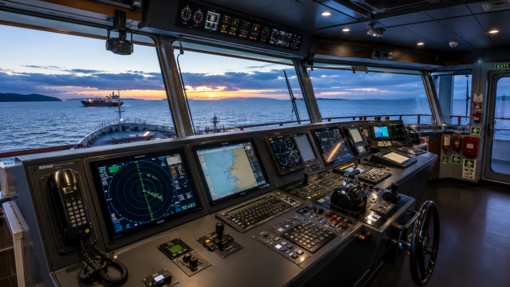
Ships move across oceans carrying millions of pounds worth of cargo. Captains and sailors need tools to know where the ship is going. They need equipment to find other ships and avoid crashes. They also need systems to stay safe in deep water and shallow water. Modern ships use many types of nautical equipment to do all these jobs.
This guide explains what these tools are and how they work. Every tool has an important job on the bridge. Together, they help ships travel through all waters without risk.
Every ship that sails in international waters must have certain equipment. These tools help captains make good decisions. They let officers see where the ship is at all times. Some tools work together to create a full picture of everything around the ship. Other tools provide backup systems if the main systems break. The equipment on ships must pass tests and inspections. Ship owners must follow international maritime laws. These laws say which equipment every ship must carry. The type and number of tools depend on the ship’s size and where it travels. Navigation equipment keeps crews safe and protects the ocean environment.
Manual chart navigation remains essential for accurate course plotting, distance measurement and position verification. These tools also provide a reliable backup when electronic navigation systems are unavailable.
The Nautical Chart Divider is a precision navigation instrument used to measure and transfer distances accurately on nautical charts. Manufactured from durable brass or stainless steel, it features adjustable sharp points for reliable performance during chart work.
Navigators use chart dividers to calculate distances and convert measurements into nautical miles using chart scales. Suitable for training vessels, commercial ships and marine academies, this essential plotting tool provides the accuracy required for safe voyage planning and bridge navigation.
The Marine Chronometer is a high-precision marine timekeeping instrument designed to provide accurate time for navigation and bridge operations. Built with a reliable quartz movement and a durable protective case, it ensures consistent performance in demanding marine environments.
Accurate time measurement is essential for navigation calculations, watchkeeping and onboard coordination. Suitable for commercial vessels, training ships and maritime institutions, the marine chronometer offers dependable operation for everyday marine applications.
The Parallel Ruler 450mm is an essential chart plotting instrument used to draw and transfer parallel lines accurately on nautical charts. Made from clear, durable plastic, it provides excellent visibility of chart details while maintaining smooth and precise movement.
The 450 mm length offers stable handling for course plotting, bearing transfer and navigation exercises. Ideal for commercial vessels, maritime training centres and navigation classrooms, it is a reliable tool for professional chart work.
The Nautical Triangle Kent-Type 300mm is a professional chart plotting tool used for measuring angles and plotting accurate courses on nautical charts. Manufactured from transparent, high-quality plastic, it allows navigators to view chart markings clearly while working. Its Kent-type design provides excellent precision and comfortable handling during navigation tasks. Suitable for ship bridges, maritime colleges and navigation training, this triangle is an essential instrument for accurate chart plotting.
The Nautical Triangle 360mm (2pcs/Set) is designed for precise course plotting and angle measurement on nautical charts. This set includes two durable transparent plastic triangles that work together with parallel rulers for efficient navigation planning.
The clear construction ensures excellent visibility of chart details while delivering accurate alignment during plotting. Widely used on commercial vessels, maritime academies and training centres, this navigation tool is ideal for professional chart work and bridge operations.
A ship must know its position, course and heading continuously. This nautical equipment provides that critical navigation information.
The magnetic compass is the oldest navigation tool on ships, with sailors relying on it for hundreds of years. This simple but effective device uses Earth’s magnetic field to point toward magnetic North, requiring no electricity to function. Even if the ship loses all electrical power during an emergency, the magnetic compass continues working reliably. This makes it the ultimate backup system for every modern vessel.
Every commercial ship carries at least one magnetic compass, and officers check it daily for accuracy. The compass must be tested and corrected at proper intervals by certified technicians. Brass construction protects the compass from salt water damage and corrosion. While modern ships rely heavily on electronic systems, the magnetic compass remains a legal requirement and a trusted fallback when technology fails.
The gyrocompass determines true North, which differs importantly from magnetic North. True North provides better accuracy for modern navigation systems and voyage planning. This sophisticated instrument spins on gyroscopic force to find Earth’s true North Pole location. Unlike magnetic compasses, it doesn’t get confused by the ship’s metal structure or the steel cargo it carries.
Modern gyrocompasses connect directly to ship computers and receiving systems. These computers integrate data from GPS, radar and other navigational instruments. When the ship makes sharp turns or encounters rough seas, the gyro shifts momentarily before automatically correcting itself. Many critical ship systems—including radar, autopilot and integrated bridge systems—depend entirely on the gyrocompass for accurate directional information.
Global Positioning System receivers use satellites orbiting Earth to provide precise location information. The satel
Modern ships use GPS data for all voyage planning activities, from route optimisation to fuel consumption estimates. The information continuously feeds into every major system on the bridge. In emergencies, GPS helps rescue services locate ships in distress quickly and accurately. This technology has revolutionised shipping more profoundly than any other single tool in maritime history, improving safety, efficiency and environmental protection.lite signals transmitted to the receiver tell officers the ship’s exact latitude, longitude, speed and course direction. The GPS system works reliably in any weather condition and at any location on Earth’s surface.
The biggest danger ships face is colliding with other vessels or running aground. These sophisticated tools help officers avoid catastrophic collisions.
Radar sends out radio waves that bounce off physical objects and return to the receiver. These waves reveal where other ships are, where land is located and where dangerous icebergs exist. Modern ships carry two types of radar for maximum coverage. X-band radar provides superior detail and clarity but struggles during heavy rainstorms. S-band radar works more effectively in severe weather conditions including heavy rain, snow and fog.
The radar screen shows the ship’s complete surroundings to the officer on watch in real time. Radar operates effectively through fog, darkness and terrible storms when human eyes cannot see anything. This technology has saved countless lives by preventing collisions in conditions where visibility is zero.
ARPA stands for Automatic Radar Plotting Aid, an advanced computer system that takes raw radar information and creates detailed tracks of other vessels. Rather than just showing where ships are at this moment, the system predicts where they will be in the future based on their current course and speed. The system calculates whether another ship poses an actual collision risk.
ARPA displays the time and distance to the closest point of approach between vessels. Officers use this critical information to plan safer routes and make course adjustments. The system provides alarms when collision risk grows beyond safe parameters, allowing officers to take evasive action immediately.
AIS uses VHF radio technology to transmit detailed ship information continuously. Every ship broadcasts its name, size, position, course and speed information. Other ships and shore-based stations receive this information automatically. AIS provides positive identification of vessels in the area.
While radar shows a target position, AIS tells officers exactly who the other ship is, what type of vessel it is and where it’s heading. This capability dramatically improves collision avoidance effectiveness. Ships in busy waters must keep AIS running at all times. International maritime law requires commercial vessels to maintain AIS transmission in all waters.
Ships must continuously know how fast they move, how deep the water beneath them is and how fast they turn. These instruments provide this vital information.
This device accurately measures the ship’s speed through the water and the total distance travelled. This information helps captains calculate when the ship will reach port and plan fuel consumption. The data goes to port authorities and maritime regulatory agencies. Officers use it to manage fuel efficiency and monitor engine performance.
The speed log helps captains steer more accurately through strong ocean currents that might otherwise push the ship off course. This becomes especially important near narrow passages and coastal areas.
The echo sounder sends sound waves downward into the water below the ship. These waves bounce off the sea bottom and return to the receiver, which measures the time delay between sending and receiving the sound. The device calculates the exact water depth from this time measurement.
Echo sounders prevent ships from running aground in shallow areas. Captains use depth information constantly in shallow water and near land areas. This technology is over one hundred years old but remains absolutely critical for maritime safety today.
This instrument shows exactly how fast the ship is turning, measured in degrees per minute. The device helps crew members execute tight manoeuvres safely. When docking in port or navigating narrow channels, this rate of turn information is vital for safe operation.
Two types exist: digital and analogue rate of turn indicators. Analogue types calculate faster and work more reliably on ships experiencing vibration and motion. Nautical equipment of this type connects directly to the steering system for real-time accuracy.
ECDIS is an advanced computer system that displays digital navigation charts, replacing paper charts on modern ships. The system connects simultaneously to GPS, radar, AIS and other equipment, creating a unified navigation picture. It shows the ship’s position without any delay or lag.
ECDIS warns officers if the ship drifts off the planned course. It displays safe routes around known dangers like reefs and shallow water. It creates an electronic log automatically without requiring human input from officers. ECDIS significantly reduces human error in navigation decisions. Maritime law requires ECDIS on most commercial ships operating internationally.
Every tool on a ship has a specific job. Together, they create a complete safety system. Magnetic compasses provide backup when electronics fail. Modern computer systems handle route planning. Radar and AIS prevent collisions. Recording devices preserve accident information. Ship owners must invest in quality equipment because lives depend on it. Maintenance and testing at the correct times keep systems working. Professional crew training ensures proper use of all equipment. Ships with reliable nautical equipment travel the world in safety and meet all maritime laws.
Modern ships use fifteen or more major types of equipment for navigation. Each tool serves a critical purpose. The bridge of a modern ship is like a control centre with many interconnected systems. Traditional compasses work alongside advanced computers. Radio systems broadcast position data. Radar sees through storms. Recording devices preserve safety information. Ships that carry reliable equipment and train their crews with care enjoy safe voyages. Every equipment investment in nautical equipment protection saves lives and prevents environmental damage. The future of shipping depends on maintaining these vital systems.